So, you’re gearing up for an epic adventure on the Tongariro Crossing? Awesome choice! But hey, I get it, planning a trek like this can feel a bit daunting.
Don’t worry, though – I’ve got your back. Let’s dive into everything you need to know to make this journey unforgettable.
What is the Tongariro Crossing, Anyway?
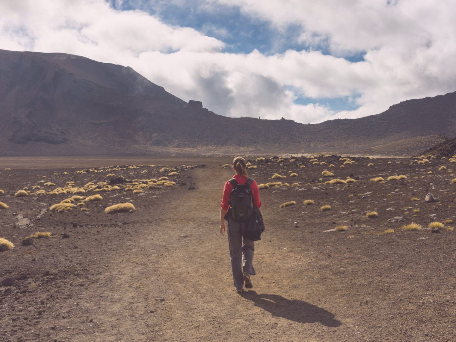
First things first, let’s set the scene. The Tongariro Crossing is often hailed as one of the best day hikes in New Zealand, and for good reason.
Picture this: stunning volcanic landscapes, emerald lakes, steam vents – it’s like stepping into a real-life Middle-earth adventure.
This 19.4-kilometer track winds its way through Tongariro National Park, a UNESCO World Heritage Site, offering jaw-dropping views at every turn.
Common Concerns: Addressing Your Worries
Now, let’s tackle some common concerns head-on:
Is it Too Difficult?
Sure, the Tongariro Crossing isn’t a walk in the park (pun intended), but it’s totally doable for anyone with a moderate level of fitness.
Take it at your own pace, and don’t forget to stop and soak in the scenery along the way.
What About the Weather?
Ah, the notorious Tongariro weather! It can be unpredictable, so come prepared with layers and waterproof gear.
Checking the forecast beforehand is a smart move, but always be ready for a sudden change – Mother Nature likes to keep things interesting.
Do I Need a Guide?
While hiring a guide is an option, the track is well-marked and heavily trafficked, making it easy to navigate on your own.
However, if you prefer peace of mind or want to learn more about the area’s history and geology, a guide can enhance your experience.
Essential Gear: Packing Like a Pro
Now, let’s talk gear. Here’s what you’ll want to pack:
Sturdy Footwear
Trust me, proper hiking boots are worth their weight in gold. The terrain can be rugged, so ankle support is key.
Layers, Layers, Layers
The weather can change on a dime, so dress in moisture-wicking layers that you can easily add or remove as needed.
Snacks and Water
Stay fueled and hydrated with plenty of water and energy-boosting snacks like trail mix, fruit, and protein bars.
Timing is Everything: Choosing the Right Season
When’s the best time to tackle the Tongariro Crossing? Well, it depends on what you’re after:
- Summer (December to February): Longer daylight hours make for more leisurely trekking, but be prepared for crowds.
- Autumn (March to May): Mild temperatures and fewer crowds make this a popular choice for many hikers.
- Winter (June to August): Snow transforms the landscape into a winter wonderland, but be ready for icy conditions and shorter daylight hours.
- Spring (September to November): Blooming wildflowers add a splash of color to the scenery, but be prepared for variable weather conditions.
Preparing for the Journey: Step-by-Step Guide
Now that you know what to expect, let’s break down the planning process into actionable steps:
Research and Booking
Start by researching the track, including its length, difficulty, and highlights.
Once you’re ready to commit, book your accommodation and transport well in advance, especially during peak seasons.
Packing Essentials
Make a checklist of essential items, including clothing, food, water, navigation tools, first aid kit, and any necessary permits or passes.
Don’t forget to check the weather forecast before finalizing your packing list.
Fitness Preparation
While the Tongariro Crossing is suitable for most fitness levels, it’s essential to prepare your body for the physical demands of the hike. Incorporate regular cardio and strength training into your routine to build endurance and strength.
Safety Considerations
Familiarize yourself with the track, including potential hazards and emergency procedures. Let someone know your itinerary and expected return time, and carry a means of communication, such as a fully charged cell phone or personal locator beacon.
Exploring the Tongariro Crossing: What to Expect
As you embark on your journey, here’s a taste of what you’ll encounter along the way:
Mangatepopo Valley
The trail begins gently, winding through the picturesque Mangatepopo Valley, with breathtaking views of Mount Ngauruhoe in the distance.
South Crater
After a steady climb, you’ll reach South Crater, a vast, flat expanse surrounded by towering volcanic peaks. Take a moment to catch your breath and marvel at the otherworldly landscape.
Red Crater
Prepare for a challenging ascent to Red Crater, the highest point on the track. The panoramic views from the summit are well worth the effort, with sweeping vistas of the surrounding mountains and emerald lakes below.
Emerald Lakes
Descending from Red Crater, you’ll encounter the iconic Emerald Lakes, a series of vividly colored volcanic pools that shimmer in the sunlight. It’s the perfect spot for a rest break and some epic photo ops.
Ketetahi Hut
The final stretch of the hike takes you through alpine meadows and native forest before reaching Ketetahi Hut, where you can refuel with a well-deserved snack and take in the serene beauty of the surrounding wilderness.
Final Tips for a Memorable Journey
Before you hit the trail, here are a few more tips to ensure your Tongariro Crossing adventure is one for the books:
- Start Early: Beat the crowds and make the most of daylight by starting your hike early in the morning.
- Respect the Environment: Leave no trace – take only photos, leave only footprints.
- Stay Safe: Familiarize yourself with the track, heed any warnings or advisories, and always prioritize safety.
Ready to Conquer the Tongariro Crossing
Armed with these tips and tricks, you’re more than ready to take on the Tongariro Crossing.
So lace up those boots, pack your bags, and get ready for an adventure you’ll never forget. See you on the trail!
Frequently Asked Questions
How long does the hike take?
The Tongariro Alpine Crossing is 19.4 km (12.1 miles) long and takes most hikers 6-8 hours to complete, including breaks. The hike has 6 main sections with the following approximate times:
- Mangatepopo Car Park to Soda Springs: 1.5 hours
- Soda Springs to South Crater: 1 hour
- South Crater to Red Crater: 1 hour
- Red Crater to Blue Lake: 0.5 hour
- Blue Lake to Ketetahi Hut: 1 hour
- Ketetahi Hut to Ketetahi Car Park: 2 hours
How difficult is the hike?
The Tongariro Alpine Crossing is considered challenging but achievable for those with good fitness levels. You’ll need to be able to:
- Walk 19.4 km in 6-8 hours
- Ascend 1,196 m (3,923 ft)
- Carry a 5-7 kg backpack with food, water and extra layers
- It’s recommended to prepare by going on some long training hikes of at least 10-15 km to assess your fitness
.
What gear is required?
It’s essential to bring the following gear for the hike:
- 1.5+ liters of water
- High-energy food and snacks
- Windproof and waterproof jacket and pants
- Hat, gloves, sunscreen, sunglasses
- Extra warm layers in your backpack
- Sturdy hiking boots or shoes
- Map, mobile phone, first aid kit
When is the best time to hike?
The best time to hike the Tongariro Alpine Crossing is during the summer months from November to April. The weather is milder and the track is open to independent hikers. In winter from May to October, the crossing can only be attempted with a guide due to snow, ice and avalanche risks
How do I get to the trailhead?
The Tongariro Alpine Crossing starts at the Mangatepopo Road end and finishes at the Ketetahi Road end. There is limited parking at the trailheads with a 4 hour time limit in summer. Most hikers leave their car at their accommodation and take a shuttle to the start. Shuttles can be booked through local operators.


